Friends of Oswegatchie Hills Nature Preserve
  • Home
  • News
    • Current News
    • Media Coverage
    • Newsletters
  • The Preserve
    • Need to Know
    • Trail Map
    • Trail Condition Info
    • Conservation Efforts
    • Environmental Studies
    • Clark Pond Bridge Project
  • Membership & Support
  • About the Friends
    • History of the Preserve
    • Stewardship & Preserve Mgmt
    • Board Members
  • Testimonials
  • Photos & Videos
    • Recent Photos
    • Videos
    • Mushroom Photos
  • Run For The Hills
  • Contact Us
    • Contact Us
    • Trail Condition Info
    • Volunteer
  • Links
Picture
​Directions

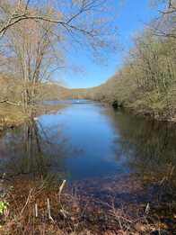
​Enter the Oswegatchie Hills Nature Preserve via Veterans Memorial Park by turning onto Memorial Park Drive off of Rte. 161. There is ample parking adjacent to the ballfields.  There is a large informational kiosk, where you can pick up a trail map before your hike and leave us your comments after! This is the southern access to both the Red and Blue Trails with vistas of both Clark and Smith Ponds. Clark Pond was created around 1900 by entrepreneur Byron Clark, the Pond served as a source of ice that fishermen used to preserve their catch (information provided by Elizabeth Hall Kuchta, East Lyme Town Historian).

 The following are not allowed:
  • Motorized Vehicles
  • Fires or Camping 
  • Firearms or Hunting 
  • Alcoholic Beverages​
  • Horseback Riding
​​Please respect the Hills
and our Neighbors
​
  • Preserve is open Sunrise to Sunset!
  • Please be careful. There are steep sections and cliffs in The Hills. Activities are done at your own risk.
  • Dogs are welcomed, but must be on a leash to protect wildlife and fellow hikers. The Hills are nature’s nursery; help protect wildlife and their young.
  • Always stay on marked trails. There are many unmarked trails in the Hills that are not indicated on the map and they WILL get you lost.
  • Please prevent against Lyme disease. Keep pants tucked inside your boots and wear light colored clothing. Always check for ticks after a hike.
  • Never hike alone. If you do, please let some-one know of your plans and call 911 in an emergency.
  • Please pick up after yourself. Litter is bad for wildlife.
  • You are responsible for your own safety.
Least Steep Trail 
​A local term sometimes used for the entire geological area boarding the west shore of the upper Niantic River is “The Hills”, referring to the Oswegatchie Hills ridgeline. And there is a reason it’s called that. It’s hilly and sections between two ridges can be steep and the terrain challenging to climb for some hikers. Those seeking a more level terrain often ask how to avoid the steep inclines. There are some sections of the trails that are fairly flat, but they will eventually lead to an incline especially if doing a loop trail. An “out and back” walk on flatter sections can be done and we recommend the following trail section if easier is your preference.
 
Try the first section of the Blue Trail going north, which you can access by going over the bridge at the OHNP Main Entrance at Veterans Field complex off Penn. Ave., Route 161. One can experience some of the beauty of the Preserve on this first section, stop at the overlook of Clark Pond and then return when it becomes too challenging.
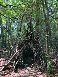
 
Trail Info
Location Markers
At each intersection there are small red metal discs with letters. These serve as location makers to assist emergency personnel if needed. Because they are also referenced on the new trail maps, hikers can use them to help identify which  intersection they are at.​
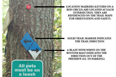
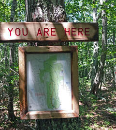
Picture
Picture
Also, thanks to the stewardship committee “You Are Here” signs and framed weatherproof maps like the photo on right are installed at key intersections to help enhance a hiker’s knowledge of their location in the Preserve.

The Rules of Social Distancing in the Hills ​

With record breaking numbers of hikers, cyclist and trail runners in the Hills we must all do our part to self-monitor and practice proper trail etiquette. We also need to be aware of new safety guidelines and how to minimize the impact of heavy usage on the environment. Your health, the health of our community and the health of the Hills depend on your careful attention to social distancing. Below is our guidance to reduce your impacts to the trail system and wildlife, while keeping yourself and others safe:

Head for the Hills When It’s Less Crowded
Plan your visits during quieter times like early morning or later in the evening. The parking lot is designed to accommodate both the athletic fields and the nature preserve. If the parking lot is more than half full, plan to come back at a different time.

Wear or Carry a Mask
It is now recommended that you wear some form of face covering on trails. If you’re not wearing one, you should have one at the ready if you hit a pinch point in the trail and can’t distance fast enough or must navigate a crowded trail.  

​Walk Single File and Use the 6 Foot Rule
Enough said…

Everyone Yields
In normal times, mountain bikers are supposed to yield to hikers and runners, but now everyone should yield first and then figure out the next move. If possible, please allow uphill traffic the right of way when meeting someone on the trail.

If Stepping off the Trail – Be Kind to the Environment
We’ve been trained not to. Stepping off-trail damages the small native plants and mosses that makes the trail hiking experience enjoyable. If you must, here’s the proper method: When approaching others, look for a place that has the least amount of small plants and where you will have minimal impact. If you have to backtrack, do so. Once you’re six feet off, wait for the approaching party to clear the area before delicately retracing your footsteps. Whether you are on foot or on wheels, don’t cut a new trail parallel to the existing track—that’s called braiding, and it’s a long-term problem because your new tracks attract other hikers. If there is more than one in your group, please all step off to the same side of the trail.

​Make Noise
Runners and cyclists need to ring bells or call out when approaching blind corners; let others know you’re coming and communicate with them to decide on a safe place to pass. We need time to make way for each other.

Always Keep Your Dog under Control
Your pet may be just as anxious to get outdoors as you are, but it’s more important than ever to ensure they are on a leash and under your control - State Statute (CGS- §22-364). As always, be sure to pick up after them and take away the poop bags. It is everyone’s responsibility to keep the Hills a clean and safe respite for you and the Preserve’s wildlife; be sure to do your part by cleaning up after your dog.

Quarry Dock Road Entrance
Permanently Closed

Picture
The decision to close this entrance was a difficult one, but was reached in mutual agreement with the town. Unfortunately, it is required due to increasingly frequent incidents that damage the environment and pose safety concerns. Ongoing inappropriate activities include trespassing, disturbances and privacy concerns associated with people parking after hours.  The parking area is also used to gain access to private property adjacent to the parking lot, as well as to Turkey Point, also on private property. The situation will be closely monitored by the Friends as well as the police. We are grateful for the continued understanding and support of our friends and visitors, and especially our members.  Please see the Revised Trail Map.
Picture
The Days Best of Readers Choice Award for Top 3 'Places to Take a Hike’!

Explore more than 450 acres of beautiful coastal forests!!!

The main entrance is via Memorial Park Drive off of Rte 161, with ample parking adjacent to the ballfields - Trail Guides available at the kiosk.
  • Home
  • News
    • Current News
    • Media Coverage
    • Newsletters
  • The Preserve
    • Need to Know
    • Trail Map
    • Trail Condition Info
    • Conservation Efforts
    • Environmental Studies
    • Clark Pond Bridge Project
  • Membership & Support
  • About the Friends
    • History of the Preserve
    • Stewardship & Preserve Mgmt
    • Board Members
  • Testimonials
  • Photos & Videos
    • Recent Photos
    • Videos
    • Mushroom Photos
  • Run For The Hills
  • Contact Us
    • Contact Us
    • Trail Condition Info
    • Volunteer
  • Links